
|
|
| STRUCTURE | |
| Abstract | Results and Discussion |
| Introduction | Conclusion |
| River discharge and climate | References |
| Material and Methods | |
| FIGURES | ||
Fig. 1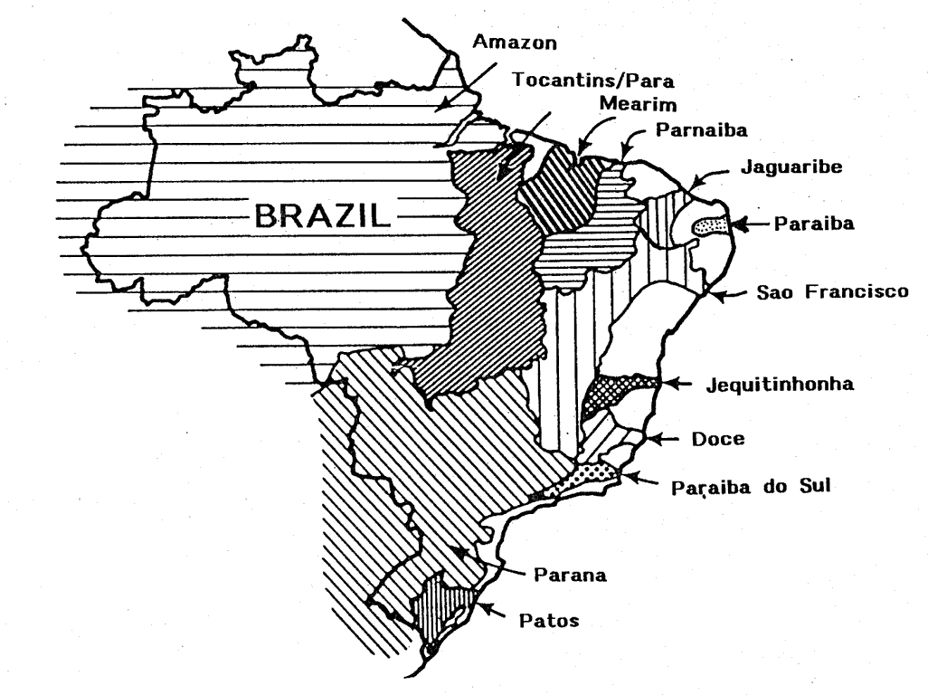 |
Fig. 2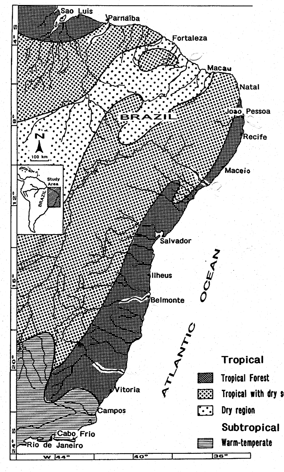 |
Fig. 3 |
Fig. 4a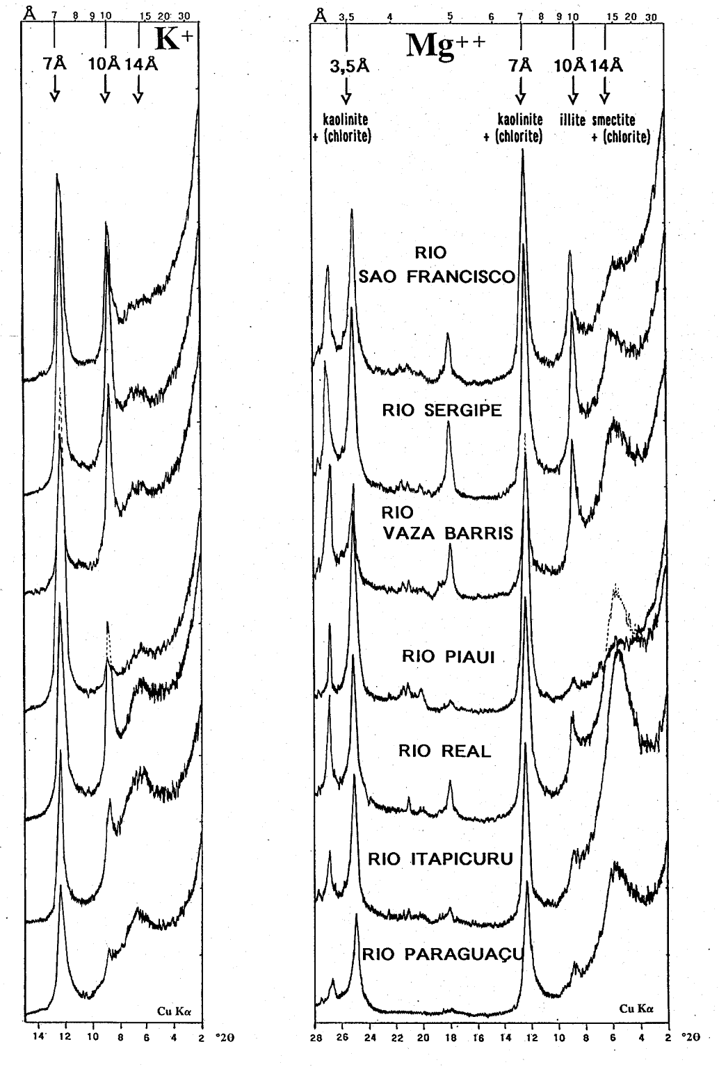 |
Fig. 4b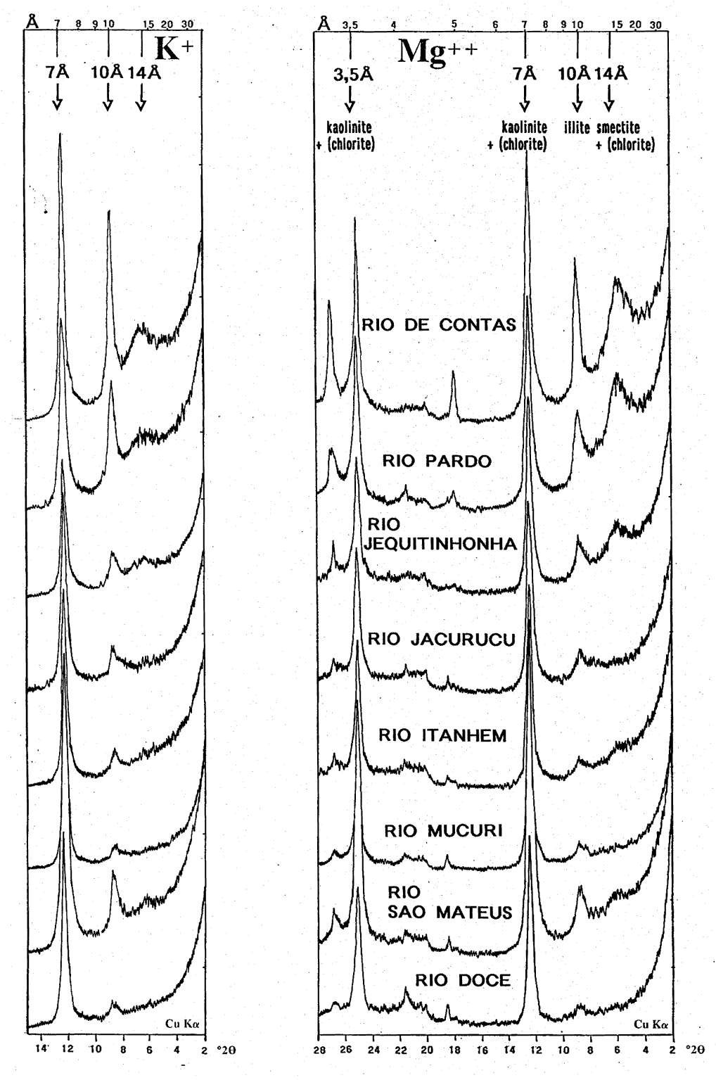 |
Fig. 5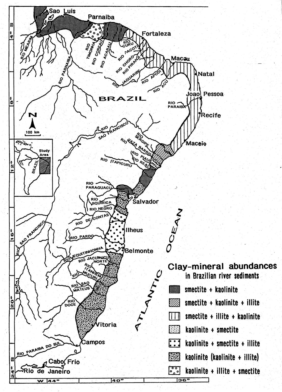 |
There is a clear smectite/illite dominance in river sediments of the northern/ north-eastern study area, whereas the southeastern/southern study area is partly characterized by extreme kaolinite abundances. This bipartition of the rivers into a northern and a southern province is based on the geology of the respective drainage areas, reflected by specific clay mineral associations.
Smectite and kaolinite constitute the main weathering products from the Paleozoic, Mesozoic and Cenozoic sedimentary basins of Piaui/Maranhao, drained by the Mearim and Parnaíba rivers, and in the case of the Pará River, from its tributary the Tocantins River, draining extensive parts of the Central Brazilian Shield. The climate in these basin areas is prevailing humid-tropical resulting in a widespread neoformation of clay minerals.
Illite and smectite, as well as higher amounts of chlorite and mixed-layer clay minerals, are the typical clay mineral constituents in the river sediments of Jaguaribe and Paraiba. They characterize a dry climate, responsible for the physical weathering conditions in the catchment areas and along the coastline. Schists, amphibolites, granites, gneisses and other metamorphics are the main source rocks of the Precambrian basement, subsequently affected by the Trans-Amazonian and Brazilian orogenic cycles.
Moving southward, the kaolinite content increases, while the amounts of illite and smectite decreases (Sao Francisco and Doce rivers). An exception are those rivers, which drain the Cretaceous Reconcavo Basin and, therefore, are characterized by extremely high smectite values. Further south, chemical (kaolinitic) weathering conditions dominate the physical weathering in the drainage basins. Kaolinite, the common weathering product of feldspars of the quartz-rich Precambrian basement rocks and the principle erosional constituent of the extensive and deeply weathered Barreiras-Formations reaches maximum values of 95%. Likewise, gibbsite and goethite, originating from the weathering of the Pre-cambrian basement, as well as soil formation and erosion, are found in the southern river sediments.
|
Fig. 1: Major drainage basins of Brazil (after milliman 1975). |
The northern rivers Pará, Mearim and Parnaíba, draining mainly tropical soils, are characterized by only slight changes in water flow between wet and dry seasons and relatively constant sediment loads (e.g. Morais 1979; Pinheiro & Faria 1987). Rivers of the NE-Brazilian inland (e.g. the rivers Jaguaribe, Açu, Paraiba and many smaller streams; see Fig. 1, 3), located within a semi-arid climate zone (see Fig. 2), the "drought polygon", deliver only small amounts of water and sediment to the Atlantic Ocean (Tintelnot 1998). This climate, which causes predominantly physical weathering conditions in the hinterland, results in several dried-up river courses over a period of some months each year (Morais pers. comm). Exceptions are rivers draining larger river basins, e.g. the rivers Jaguaribe, Açu and Paraiba, and rivers being affected by a more tropical climate along a narrow belt of the coastline (Fig. 2). The generally low content of suspended load in NE-Brazilian rivers are due to the absence of a young, rugged topography and to the predominantly semi-arid climate.
Aridity is responsible for the low amount of suspended matter provided by the Sao Francisco River (Coutinho 1969), although sporadic rainfalls may cause momentary high concentrations in the river water (Coleman & Wright 1971, Jennerjahn et al. 1996).
The mountainous coast of southeastern Brazil is an area of high rainfall,
tropical vegetation (see Fig. 2) and small coastal
rivers, with much of their drainage being directed inland. Low concentrations
of suspended matter in the near-coastal surface waters indicate that probably
very little terrigenous sediment presently reaches the continental shelf.
|
Fig. 2: Distribution of the climatic zones along the NE-SE coast from Brazil. Most parts of the investigated area are affected by a warm-tropical climate (modified from zeil 1986). |
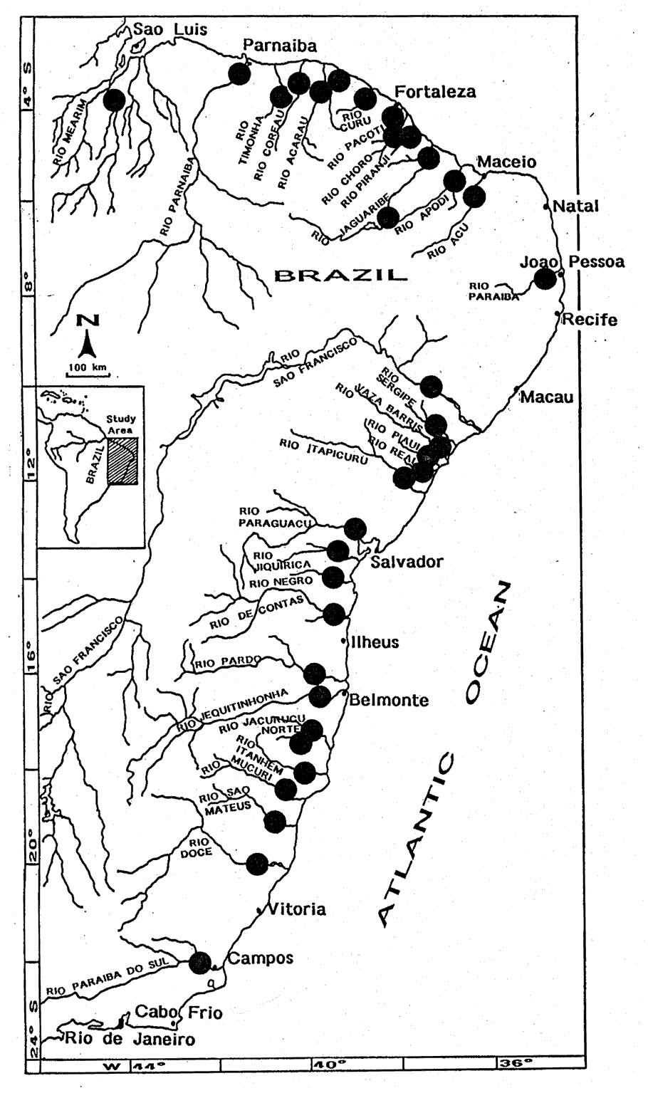 |
Fig. 3: River samples taken along the Brazilian coastline between Sao Luis and Cabo Frio. |
|
Fig. 5: Clay mineral associations and their relative abundances in Brazilian river. |
In the northeastern part of Brazil, a close relation between the main clay minerals smectite, illite and kaolinite is characteristic for the short coastal rivers. They originate from predominantly Proterozoic/Precambrian magmatic and metamorphic rocks in the catchment areas. Due to physical weathering conditions in the semi-arid northeast (apart from a small belt of humid tropical climate parallel to the coastline; Fig. 2), the clay-mineral fraction in the sediments of the more extensive drainage systems of this region is dominated by illite (e.g. Acu River; Fig. 4a). However, unusually high smectite contents appear locally (e.g. River Acaraú; Fig. 5). Here, in addition to Precambrian basement rocks, the catchment areas drained by these rivers also include areas rich in volcanic rocks. High smectite amounts correlate mostly with higher values of mixed-layer clay minerals. Generally, chlorite and random mixed-layer minerals are found in traces in some of the river sediments. Especially in the more eastern part, smaller tributaries, like some partly ephemeral, partly intermittent streams and further creeks, do not transport any sediment to the Atlantic Ocean (Morais pers. comm.). Most riverborne sediments, yielded during the short annual rainy season, remain trapped in the mangrove-fringed, estuarine-like river mouths. A narrow belt of Quaternary sediments and Tertiary outcrops parallel to the NE-Brazilian coastline (Mabesoone 1966, Mabesoone et al. 1972) may partly be responsible for the clay mineral assemblages (with more kaolinite) found in the river sediments.
The clay mineral distribution in sediments of the rivers Jaguaribe,
a so-called dry river (Morais pers. comm.), and Apodi are very different
compared to the above described clay mineral associations (Fig.
4a). Smectite is the predominant clay mineral. Illite values are lower,
despite the surrounding Proterozoic basement and the prevailing physical
weathering conditions in the catchment areas (Mabesoone 1966). Most
of the mountaineous hinterland is underlained by several Precambrian units,
mainly formed by gneiss and migmatites. A kaolinite amount of 27 % in the
clay fraction of the sediments in both rivers was measured. Chlorite was
not found. These changes in clay mineral composition may also originate
from sedimentary Cretaceous and Tertiary (Barreiras-Formation) outcrops
of the Potiguar Basin. In addition, Cretaceous outcrops and a few smaller
Tertiary patches are located in the upper courses of both rivers, covering
the Proterozoic basement. Also, Tertiary sediments of the Barreiras-Formation
are still exposed along the upper course of the Jaguaribe River. All these
relatively young sediments may cause the conspicuous enrichment of smectite
and kaolinite in this limited area. The clay mineral association of the
Jaguaribe River, with its mainly arid hinterland, and of the River Apodi
can not be the result of today's climate. The dominance of kaolinite and
smectite suggests, that in the past the climate in the drainage area of
these rivers was more humid (Irion et al. 1989, Tintelnot
1998).
|
Fig. 4a: X-diagrams of the clay fraction ( < 2 µm, Mg++- and K+-saturated) from NE-SE-Brazilian river sediments (along the coastline between the Sao Francisco River and the Todos os Santos Bay). |
|
Fig. 4b: X-ray diagrams of the clay fraction ( < 2 µm, Mg++- and K+-saturated) from SE-Brazilian river sediments (along the coastline between the rivers De Contas and Doce). |
The Sao Francisco River, which was sampled during some field trips, is the second largest river system of Brazil, with a length of 2,700 km. Its drainage basin has an expansion of more than 630,000 km2 (Coleman & Wright 1971) and ranges on number 31 on the worldwide list of river-basin areas. It has an annual mean water discharge of 99 km3 (Bessa & Paredes 1990). The annual sediment discharge of 6·106 t is influenced by the construction of dams and the related retention of sediments in reservoir lakes (e.g. Milliman 1975, Milliman et al. 1995). The Sao Francisco River crosses a wide range of areas with different climatic and geological features. Its entire drainage basin is contained within and surrounded by the Sao Francisco Craton (Atlantic Shield) and its marginal fold belts. Cretaceous and even younger Tertiary and Quaternary sediments cover the Precambrian basement to the western side along the upper and middle river course and form the Sao Francisco sedimentary cover. Lithologies found in the drainage basin comprise essentially Precambrian sedimentary rocks, mostly limestones and quartzites with few exposures of the crystalline basement. Silica contents of river waters seem to be a reflection of the geology of the Sao Francisco Basin (Paredes et al. 1983). The average sediment load of the Sao Francisco is 64 mg/l, ranging between 270 mg/l and 1 mg/l. The great variabilities of its sediment load could be explained by the variations in sand and mud bank erosion and the sedimentation due to turbulence and local shifting of higher-speed currents (Coutinho 1969).
The river is located in the wet-and-dry tropics (Fig. 2) and affected by a pronounced seasonality of precipitation and runoff. Moisture surplus is significant throughout the year, with the maximum in December nearly 100 times higher than the minimum in October (Coleman & Wright 1971). The upper basin is situated in the humid tropical region. Parts of the middle basin and the entire lower middle basin belong to the so-called "drought polygon", the semiarid area of the Northeast. Dominguez et al. (1992) maintain that this semi-arid climate is characteristic for most parts of the drainage basin with annually six or more dry months. This aridity reaches the coastal zone where the Sao Francisco River enters the Atlantic Ocean. As a consequence of the diversity of climates, a great variety of hydrobiogeochemical features is observed along the river, especially in the upper region (Paredes et al. 1983). Here, the tropical river basin experiences extreme chemical and biological weathering, thus shedding large quantities of fine-grained sediments resulting in a high suspended sediment load of the Sao Francisco River. During the last decades and still recently, a great part of the suspended load is deposited in the reservoirs of several dams (Tintelnot & Irion 1998).
In general, all sediment samples from the Sao Francisco River were taken from its middle and lower river course. They show almost identical clay mineral assemblages, dominated by kaolinite (44 %) and illite (40 %), and by surprisingly low amounts of smectite (16 %; Fig. 4a). Widespread outcrops of Cretaceous carbonates covering the catchment area of the middle river course may be responsible for smectite-rich sediment loads (Oliveira 1983). Low erosion rates, affected by a predominantly dry climate (more than six months without rain), reduce the sediment input (Oliveira 1975) and dams prevent a further transport to the ocean. Therefore, most of the illite- and kaolinite-rich sediments, obtained from near-coastal and river mouth samples, can be traced back to the outcropping Precambrian crystalline basement (illite) and the Tertiary Barreiras-Formation (kaolinite) in the middle and lower river course. Here, physical weathering conditions dominate. Further clay minerals, like the expected chlorites and mixed-layers, have not been found. Traces of gibbsite and goethite are present in some of the samples. Almost identical clay mineral assemblages have been found in Sergipe River sediments (Fig. 4a).
Sediments of the rivers Real and Itapicuru are slightly different in their clay-mineral composition, being affected by the Cretaceous and Tertiary outcrops of the Recôncavo (Tucano) Basin and coastal alluvial sediments. Both rivers, as well as the Vaza Barris River, cross this basin on their way to the South Atlantic.This is reflected in the abundance of smectite (up to more than 60 %) and the relatively lower amounts of illite (Fig. 4a). The Vaza Barris River, like the Itapicuru River, has its source in the mountaineous region of the Sao Francisco Craton, which is built up by outcrops of the Precambrian basement. Nevertheless, smectite is the prevalent clay mineral in sediments of the Itapicuru River, whereas the clay mineral associations of the Vaza Barris River and, surprisingly of the Real River, which originates in the Recôncavo Basin, are dominated by kaolinite and illite (Fig. 4a). Summarizing, the clay mineralogical results show that illite is more typical for the arid weathering conditions in the upper river courses (e.g. Vaza Barris River). Kaolinite, however, is associated to more chemical weathering conditions under the influence of a tropical climate in the lower river courses, which are surrounded by Precambrian and Tertiary outcrops (e.g. rivers Piaui and Real). Especially Itapicuru River sediments reflect the long passage through the Recôncavo Basin resulting in the already mentioned high smectite contents. Moreover, they are associated with relatively high amounts of mixed-layer clay minerals. Only a small part of the catchment area in the lower river course is formed by almost exclusively Tertiary sediments from the Barreiras-Formation, which causes relatively low illite and kaolinite values. Therefore, the input of eroded material either from Precambrian basement upstream or from Tertiary outcrops downstream is low (Tintelnot et al. 1996). The last X-ray diagram in figure 4b shows the clay mineral association of the Paraguaçu River. This river is nowadays interrupted by several dams along its course (Brichta pers. comm.) and transports little sediment to the Todos os Santos Bay (Bittencourt et al. 1976). Geological units and the climatic zonation along this river course are similar to the conditions in the drainage basin of the Itapicuru River. Therefore, almost identical clay mineral as-semblages have been found in these river sediments (Fig. 4a).
Moving southward, the Jequitinhonha and Jacurucu Norte rivers show similar clay mineral distribution patterns, with however slightly lower smectite amounts (Fig. 4b). The Jequitinhonha River, 800 km in lenght and draining a catchment area of 69,000 km2 (e.g. Milliman 1975), has its source also in the eastern mountaineous range of the Atlantic Shield, crossing the Precambrian basement (not covered by Tertiary sediments) and Tertiary coastal sediment deposits. Additionally, traces of gibbsite and goethite, which are characteristic products of the chemical weathering, have been found in sediments of both rivers.
The southern rivers of Bahia (Jacurucu Sul, Itanhem and Mucuri) and Espirito Santo (Sao Mateus and Doce) are distinguished from all others by their high kaolinite values and partly small amounts of illite (Fig. 4b). There is no smectite, except for the Sao Mateus River (3 %). The high content of kaolinite (> 75 %) originates from the kaolinitic weathering of the Precambrian basementand from the intensive erosion of the Tertiary Barreiras-Formation common to the catchment area of these rivers. All rivers, except for the Doce River, are rather short with very small drainage basins. They have their sources in the coast-parallel mountaineous range built up by the Precambrian basement, where extreme chemical (kaolinitic) weathering conditions prevail, which erode and drain mainly schists and metamorphic rocks in the upper stream courses. The lower river courses are dominated by widespread sedimentary deposits from the Barreiras-Formation, covering the coastal "lowlands" up to a width of 50 km and cut deep valleys in these plains. These conditions produce a more or less mono-mineralic clay mineral assemblage with high kaolinite abundances and small amounts of illite, whereas smectite was almost not measureable. Traces of Fe- and Al-rich minerals, like gibbsite and goethite, were found in the river sediments depending on the prevailing weathering conditions and the strong erosional activities, especially in the lower part of the drainage basins.
The Doce River, 750 km in lenght and draining a catchment area of 83,000 km2 (Suguio et al. 1982), originates from the mountaineous hinterland. It crosses the crystalline Precambrian basement, which is covered by a thick weathering mantle, and the Tertiary coastal sediments of the Barreiras-Formation. Peculiar to its drainage basin is the relatively high humidity in this area when compared to the catchment areas of the northern rivers. According to Andrade (1964) the rainfall regime classifies the climate as being equatorial (Fig. 2), which affects especially the vegetation and weathering conditions in the lower course of the Doce River. Prevailing kaolinitic weathering of the Precambrian basement and similar conditions along the Tertiary coastline result in a dominance of kaolinite and smaller amounts of illite, as well in the presence of gibbsite and goethite (Fig. 4b). Smectite, mixed-layers and chlorite were not found in the river sediments analyzed.
There is a clear smectite/illite dominance in river sediments of the northern/northeastern study area, whereas the southeastern/southern study area is partly characterized by extreme kaolinite abundances (Fig. 5). This bipartition of the rivers into a northern and a southern province is based on the geology of the respective drainage areas, reflected by specific clay mineral associations.
Smectite and kaolinite constitute the main weathering products from the Paleozoic, Mesozoic and Cenozoic sedimentary basins of Piaui/Maranhao, drained by the Mearim and Parnaíba rivers, and in the case of the Pará River, from its tributary the Tocantins River, draining extensive parts of the Central Brazilian Shield. The climate in these basin areas is prevailing humid-tropical resulting in a widespread neoformation of clay minerals.
Illite and smectite, as well as higher amounts of chlorite and mixed-layer clay minerals, are the typical clay mineral constituents in the sediments of the rivers of the States Ceara, Rio Grande do Norte and Paraiba, but also of the largest rivers of this region, the Jaguaribe and Paraiba (Fig. 5). Their drainage basins are characterized by a dry climate, responsible for the physical weathering conditions in the catchment areas and along the coastline. Schists, amphibolites, granites, gneisses and other metamorphics are the main source rocks of the Precambrian basement, subsequently affected by the Trans-Amazonian and Brazilian orogenic cycles.
Moving southward, the kaolinite content increases, while the amounts of illite and smectite decreases (Sao Francisco and Doce rivers; Fig. 5). An exception are those rivers, which drain the Cretaceous Recôncavo Basin and, therefore, are characterized by extremely high smectite values. Further south, chemical (kaolinitic) weathering conditions dominate the physical weathering in the drainage basins. Kaolinite, the most common weathering product of feldspars of the quartz-rich Precambrian basement rocks and the principle erosional constituent of the extensive and deeply weathered, coast-parallel Tertiary Barreiras-Formations reaches maximum values of 95 % of the clay mineral content. Likewise, gibbsite and goethite, originating from the weathering of the Precambrian basement and from soil formation and erosion, are found in thesouthern river sediments (Fig. 4b).
In conclusion, this study aims to establish a synopsis of the source and composition of clay minerals in NE and SE Brazilian rivers. Their characteristic distribution patterns largely reflect regional differences of their source areas.
ATTERBERG, A. (1912): Die mechanische Bodenanalyse und die Klassifikation der Böden Mittelschwedens.- Int. Mitt. f. Bodenkunde: 1-314; Göttingen.
BESSA, M. F., PAREDES, J. F. (1990): Transporte do carbono e do nitrogênio orgânico e inorgânico dissolvidos pelo rio Sao Francisco, Brasil, durante um ano hidrológico (1984-1985).- Geochim. Brasil, 4: 17-31; Rio de Janeiro.
BITTENCOURT, A. C. S. P., FERREIRA, Y. A, NAPOLI, E. (1976): Alguns aspectos da sedimentaçao na baia de Todos os Santos, Bahia.- Rev. Bras. Geoc., 6: 246-263
COLEMAN, J. M, WRIGHT, L. D. (1971): Analysis of major river systems and their deltas: Procedures and rationale, with two examples.- Coast. Stud. Ser., 28: 1-125; Louisiana (State Univ. Press).
COUTINHO, P. N. (1969): Sedimentation at the mouth of the Sao Francisco River (Brazil).- Trab-s. Inst. Oceanogr. Univ. Fed. Pe., 9/11: 41-50; Recife.
DEPETRIS, P. J, PAOLINI, J. E. (1991): Biogeochemical aspects of South American rivers: The Paraná and the Orinoco.- In: Degens, E. T., Kempe, S, Richey, J. E. (eds.): Biogeochemistry of Major World Rivers.- SCOPE Rep. 42: 105-125; Chichester, New York, Brisbane (Wiley & Sons).
DOMINGUEZ, J. M. L., BITTENCOURT, A. C. S. P, MARTIN, L. (1992): Controls on Quaternary coastal evolution of the east-northeastern coast of Brazil: roles of sea-level history, trade winds and climate.- Sedim. Geol., 80: 213-232; Amsterdam.
EISMA, D. (1988): The terrestrial influence on tropical coastal seas.- In: Mitt. Geol.-Paläont. Inst. Univ. Hamburg, SCOPE/UNEP Sonderbd. 66: 289-317; Hamburg.
IRION, G. (1983): Clay mineralogy of the suspended load of the Amazon and of rivers in the Papua-New Guinea Mainland.- In: Degens, E. T, Kempe, S. (eds.): Transport of Carbon and Minerals in Major World Rivers, Pt. 2.- Mitt. Geol.-Paläont. Inst. Univ. Hamburg, SCOPE/UNEP Sonderbd. 55: 483-504; Hamburg.
IRION, G., MORAIS, J. O, WUNDERLICH, F. (1989): Geologische Studien an einem Küstenstreifen NE-Brasiliens (Ceará).- Nat. u. Mus., 119: 158-166; Frankfurt/M.
JACKSON, M. L. (1965): Clay transformations in soil genesis during the Quaternary.- Soil. Sci., 99: 15-22.
JENNERJAHN, T. C., ITTEKKOT, V, CARVALHO, C. E. V. (1996): Preliminary data on particle flux off the Sao Francisco River, eastern Brazil.- In: Ittekkot, V., Schäfer, P., Honjo, S, Depetris, P. (eds.): Particle Flux in the Ocean.- SCOPE Rep. 57: 215-222; Chichester, New York, Brisbane (Wiley & Sons).
KLINGE, H, OHLE, W. (1964): Chemical properties of rivers in the Amazonian area in relation to soil conditions.- Verh. Internat. Verein. Limnol., XV: 1067-1076; Stuttgart.
LISITZIN, A. P. (1972): Sedimentation in the world ocean.- SEPM Spec. Pub., 17: 1-218; Tulsa, Ok.
MABESOONE, J. M. (1966): Relief of northeastern Brazil and its correlated sediments.- Zeitschr. Geomorphol., NF 10: 419-453; .
MABESOONE, J. M., CAMPOS E SILVA, A, BEURLEN, K. (1972a): Estratigrafia e origem do grupo barreiras em Pernambuco, Paraiba e Rio Grande do Norte.- Rev. Bras. Geoc., 2: 173-188; Sao Paulo.
MEADE, R. H., DUNNE, T., RICHEY, J. E., SANTOS, U. M, SALATI, E. (1985): Storage and remobilization of suspended sediment in the Lower Amazon River of Brazil.- Science, 228: 488-490; Washington, D.C.
MILLIMAN, J. D. (1975): Upper continental margin sedimentation off Brazil: Part VI: A Synthesis.- Contr. Sediment., 4: 151-175; Stuttgart.
MILLIMAN, J. D. (1991): Flux and fate of fluviatil sediment and water in coastal seas.- In: Mantoura, R. F. C., Martin, J.-M, Wollast, R. (eds.): Ocean Margin Processes in Global Change.- Dahlem Workshop Rep. 9: 69-89; Chichester, New York, Brisbane (Wiley & Sons).
MILLIMAN, J. D, MEADE, H. R. (1983): World-wide delivery of river sediment to the oceans.- J. Geol., 91: 1-21; Chicago, Ill.
MILLMAN, J. D., RUTKOWSKI, C, MEYBECK, M. (1995): River discharge to the sea: A global river index (GLORI).- LOICZ Rep, Stud. 2: 1-125; AB Den Burg
MILLIMAN, J. D, SYVITSKI, J. P. M. (1992): Geomorphic/tectonic control of sediment discharge to the ocean: the importance of small mountainous rivers.- J. Geol., 100: 525-544; Chicago, Ill.
MOHR, E. C. J., VAN BAREN, F. A, VAN SCHUYLENBORGH, J. (1972): Tropical Soils - A Comprehensive Study of their Genesis.- 1-481; The Hague, Paris, Djakarta (Mouton-Ichtiar Baru-van Hoeve).
MORAIS, J. O. (1979): Processos de sedimentaçao na baia de Sao Marcos, Nordeste do Brasil.- Atas IX. Simp. Geol. Nordeste, 150-165; Natál.
OLIVEIRA, J. J. (1975): Implicaçoes paleoclimatices e pedogenetices no estudo da alteraçao incipiente das rochas granito - gnaissicas na regiao centro - ocidental da Bahia.- An. Acad. bras. Ci., 47: 243-247; Rio de Janeiro.
OLIVEIRA, J. J. (1983): Lateritic soils profile in semiarid environment: pedological, geochemical and mineralogical data.- In: Melfi, A. J, Carvalho, A. (eds.): Lateritisation Processes.- Proc. 2nd. Int. Sem. Lateritisation Processes, 499-506; Sao Paulo.
PAREDES, J. F., PAIM, A. J., DORIA, E. M. C, ROCHA, W. L. C. (1983): Sao Francisco River: hydrobiological studies in the damned lake of Sobradinho.- In: Degens, E. T, Kempe, S. (eds.): Transport of Carbon and Minerals in Major World Rivers, Pt.2.- Mitt. Geol.-Paläont. Inst. Univ. Hamburg, SCOPE/UNEP Sonderbd. 55: 193-202; Hamburg.
PINHEIRO, R. V. L, FARIA, L. E. C.Jr. (1987): Processos sedimentares recentes no estuário Guajará - Belem.- 1° Congr. ABEQUA: 119-132; Porto Alegre.
SUGUIO, K., MARTIN, L, DOMINGUEZ, J. M. L. (1982): Evoluçao da planicie costeira do Rio Doce (ES) durante o Quaternario: influência das fluctuaçoes do nivel do mar.- Atas IV. Simp. Quat. Brasil, 93-116; Rio de Janeiro.
TINTELNOT, M. (1998, in press): Fine-grained terrigenous material in the western equatorial Atlantic as an indicator of NE Brazilian climate and sea-level fluctua-tions during the Late Quaternary.- Zbl. Geol. Paläont. Teil I, 1997, H. 3/4
TINTELNOT, M., BRICHTA, A., MORAIS, J. O, IRION, G. (1996): Heavy metal concentrations and clay mineral composition in fine-grained river sediments on the Brazilian coast.- Anais XXXIX Congr. Bras. Geol., Salvador (BA), 1: 315-319.
TINTELNOT, M, IRION, G. (1998): Transport and deposition of fine-grained sediments on the Brazilian continental shelf as revealed by clay mineral distribution. - Cour. Forsch.-Inst. Senckenberg; Frankfurt/M. [In press]
TINTELNOT, M., JENNERJAHN, T.C., HÜBNER, M., IRION, G., ITTEKKOT, V., MORAIS, J. O, BRICHTA, A. (1994b): Sedimentological and geochemical indicators of river supply along the Brazilian continental margin.- Ber. FB Geow., Univ. Bremen, 52: 154-156; Bremen.
ZEIL, W. (1986): Geologie der Erde: Südamerika.- 1: 1-160; Stuttgart (Enke).